
What Your Survey Plat Map Is Really Showing You
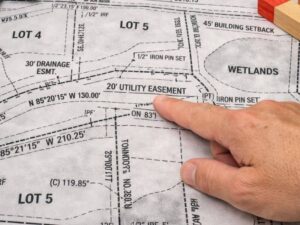 When a land surveyor finishes working on your property, they hand you a drawing called a survey plat. It is full of numbers, lines, arrows, and abbreviations. At first glance, it can look very confusing.
But once you learn the basics, a survey plat is not hard to read at all. It is a carefully drawn map of your land, and every line, number, and symbol has a specific meaning.
What Is a Survey Plat Map?
A survey plat is an official, scaled drawing of your property made by a licensed land surveyor. It shows the exact size, shape, and boundaries of your land. It also shows features like easements, structures, and property corners.
A survey plat is a legal document. It can be used for building permits, property disputes, real estate closings, and government filings.
It is important to know the difference between a survey plat and an online map. Online property maps from Google or county websites are useful, but they are not perfectly accurate. A survey plat is based on real measurements taken on the ground by a licensed professional. It is far more reliable for legal purposes.
Step 1: Start With the Title Block
The first thing to find is the title block, usually located in the lower right corner of the drawing. Think of it as the cover page of the survey. It gives you the most important details about the document.
The title block will show:
- The property owner’s name
- The property address or legal description
- The type of survey, such as “Boundary Survey” or “Location Survey”
- The surveyor’s name, license number, and official seal
- The date the survey was completed
- The drawing scale
Always check the date. An older survey may not show recent changes to the property, such as a new structure or a newly recorded easement.
Step 2: Find the North Arrow
The north arrow is a simple arrow, usually labeled “N,” that shows which direction is north on the drawing. Always find this before reading anything else.
Once you know which way is north, you can understand how your property lines up with nearby roads, neighboring lots, and other landmarks around it.
Step 3: Understand the Scale
The scale tells you how the drawing relates to real distances on the ground. A scale of 1 inch = 40 feet means that every inch on the drawing represents 40 feet in real life.
Most plats also include a graphic scale bar, which looks like a small ruler drawn on the map. You can use a regular ruler alongside it to measure distances on the drawing and convert them to real-world feet.
Step 4: Read the Boundary Lines
The thick, solid lines that form the outer shape of the drawing are your property boundaries. These show exactly where your property begins and ends.
Look at each line segment along the boundary. You will see two pieces of information written beside each one.
The first is the bearing, which shows the direction of that line. It looks something like this: N 45 30 15 E. This means the line travels north, angled 45 degrees toward the east. The bearing simply describes which direction each boundary line runs.
The second is the distance, which tells you how long that line is. Distances are shown in feet, such as 150.25 feet.
At each corner of your property, you will see a small symbol. These represent physical markers that your surveyor either found or placed on the ground. Common markers include iron pins, rebar, and concrete monuments. The legend explains what each symbol means.
Step 5: Use the Legend
The legend is a box on the drawing that explains what each symbol and line type means. Always check the legend before drawing any conclusions from what you see on the plat.
Common symbols and what they usually mean:
- Dashed lines represent easements or setback lines
- Shaded areas show rights-of-way or drainage zones
- “R/W” stands for right-of-way
- “U/E” stands for utility easement
- “D/E” stands for drainage easement
- “B/L” stands for building setback line
Step 6: Understand Easements
Easements are one of the most important things to look for on your plat. An easement is a legal right that allows someone else to use part of your property for a specific purpose.
Common easements include utility easements, which allow power or water companies to run lines across your land. Drainage easements allow water to flow through a section of your property. Access easements give a neighbor or the public the right to cross your land to reach another parcel.
Easements are shown as dashed lines or shaded strips with a written label. If an easement references a book and page number, it is officially recorded in your county’s land records. Knowing this is important before placing a fence, shed, or any other structure on your property.
Step 7: Read the Surveyor’s Notes
Near the title block or along the edge of the plat, you will often find written notes from the surveyor. These notes explain things that cannot be shown clearly in the drawing alone.
Notes may include information about flood zones, zoning setbacks, conflicts between old deed records and current measurements, or easements that were recorded but could not be physically found during the survey. Always read these notes carefully. They often contain details that are just as important as anything shown on the drawing itself.
Step 8: Walk Your Property With the Plat
After you understand your plat, take it outside and walk the land. Try to find the physical corner markers that match the corners on the drawing. These are usually iron pins or rebar driven into the ground.
If you cannot find a corner marker, do not assume it is missing. It may be buried under grass, hidden by a fence, or sitting at the edge of a driveway. A licensed surveyor can help you locate them if needed.
Frequently Asked Questions
Can I use my plat map to install a fence?
Your plat shows where your property lines are, but you should confirm the physical corner markers on the ground before building. Relying on the drawing alone, without finding the actual markers, can result in a fence being placed in the wrong spot.
Where can I get a copy of my plat map?
If the plat has been recorded, you can request a copy from your county register of deeds or courthouse. If it has not been recorded, the surveyor or the original property owner may have the only copy on file.
Is a plat map the same as a tax map?
No. Tax maps are maintained by the county for tax purposes and are based on estimates. A survey plat is prepared from actual field measurements and is a legal document. Tax maps are useful for general reference but should never be used for legal boundary decisions.
For a free land surveying quote, call us at (256) 770-8662 or send us a message by going here.
Posted in land surveying, land surveyor |