
What Can a Topographic Survey Tell You?
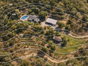 If you have ever talked to an architect, engineer, or contractor about a project on your property, there is a good chance they asked for a topographic survey. Many property owners have never heard of one before, and even fewer know what it actually shows.
A topographic survey is different from other types of surveys. It does not just tell you where your property lines are. It tells you what the land itself looks like. Understanding this difference could save you from costly mistakes before any work begins.
What Is a Topographic Survey?
A topographic survey is a detailed map of your land that shows its shape, height, and features. It captures both the natural elements and the man-made structures found on the property.
A licensed land surveyor uses tools like GPS receivers, total stations, and sometimes drones to collect measurements across your land. Those measurements are then turned into a drawing that shows:
- The highs and lows of the land, shown as contour lines
- Natural features like trees, streams, slopes, and low-lying areas
- Existing structures like buildings, driveways, fences, and walls
- Utility lines that run above or across the property
- Specific elevation points at key locations on the lot
The final product is a scaled drawing that engineers, architects, and government agencies use when planning any project on or near your property.
How Is It Different From a Boundary Survey?
A boundary survey focuses on one thing: where your property lines are. It marks the corners and edges of your land so you know exactly what you own.
A topographic survey goes further. Instead of just showing where the land ends, it shows what the land looks like in between. It captures the rise and fall of the ground, the location of trees and drainage channels, and the position of any structures already on the lot.
In many projects, both surveys are done together. A surveyor may first establish the property boundaries and then layer in all the topographic details. This gives the design team a complete picture of the land before any planning begins.
When Do You Need a Topographic Survey?
There are several common situations where a topographic survey is either required or strongly recommended.
Before Building a New Home or Structure
Any new construction project needs accurate information about the land’s slope and drainage. Architects use topographic data to design foundations that are safe and properly supported. Engineers use it to plan how water will flow away from the structure. Without this information, expensive problems can show up during or after construction.
When Applying for a Building or Grading Permit
Most local governments require a topographic survey as part of the permit process. This is especially true for any project that involves grading, excavation, or significant changes to the land. If you plan to add a large structure, a retaining wall, or a stormwater system, check with your local building department about what is required.
For Drainage and Flooding Problems
If your yard collects water after heavy rain, or if you have noticed erosion on your property, a topographic survey gives professionals the data they need to fix the problem correctly. A drainage contractor or civil engineer will use the elevation data to design a system that redirects water away from your home and yard.
For Landscaping and Grading Projects
Large landscaping projects, especially those that involve regrading the land or installing new drainage, require an accurate picture of the existing terrain. A topographic survey provides that picture so your landscape designer can work with the natural shape of the land rather than against it.
For Land Development and Subdivision
If you plan to divide a property or develop land for commercial or residential use, a topographic survey is a required first step. Engineers cannot design roads, utilities, or stormwater systems without accurate elevation data. Skipping this step can cause major delays and added costs later in the project.
When an Architect or Engineer Requests One
If you hire a professional to design any improvement to your property, they will almost always ask for a topographic survey before starting their work. The survey gives them the information they need to create a design that is safe, functional, and code-compliant.
What Does the Finished Survey Show?
When your surveyor delivers the completed topographic survey, the drawing will typically include:
- Contour lines, which are curved lines connecting points of equal elevation. When lines are close together, the land is steep. When they are far apart, the land is flat.
- Spot elevations, which are specific height measurements at important points on the property
- Existing structures, including the location and rough dimensions of buildings and other improvements
- Natural features, such as trees, ditches, and water bodies
- A scale, north arrow, and benchmark reference, which tie the drawing to real-world measurements
How Long Does a Topographic Survey Take?
For a typical residential property, fieldwork usually takes one to two days. After that, the surveyor needs time to process the data and produce the final drawing, which can take several more days. Larger properties or those with difficult terrain may take longer.
If you are working toward a permit application or a construction start date, reach out to your surveyor early. Delays in receiving the survey can push back the entire project timeline.
Do You Always Need a Separate Topographic Survey?
Not always. In some cases, your surveyor can combine the topographic data with other survey work being done at the same time, such as a boundary survey or a construction staking survey. This can reduce both cost and time.
Ask your surveyor whether a combined survey makes sense for your specific project. They can advise you on the most efficient approach based on what your architect or engineer needs.
Frequently Asked Questions
Is a topographic survey the same as an elevation certificate?
No. A topographic survey maps the full shape and features of your entire property. An elevation certificate is a specific FEMA document that records your building’s lowest floor height in relation to the flood zone. They use similar data, but they serve very different purposes.
Who orders a topographic survey?
Property owners, developers, architects, civil engineers, and government agencies all order topographic surveys depending on the project. In most cases, your architect or engineer will tell you exactly what they need.
Can the survey data be used by my designer?
Yes. Surveyors typically deliver the data in a file format that is compatible with design software like AutoCAD or Civil 3D. When requesting a quote, confirm the file format your designer needs so the data can be used directly without extra conversion steps.
For a free land surveying quote, call us at (256) 770-8662 or send us a message by going here.
Posted in land surveying, land surveyor |