
From Cotton Fields to Cul-de-Sacs: Land Surveying Challenges in Fast-Changing Rural Parcels
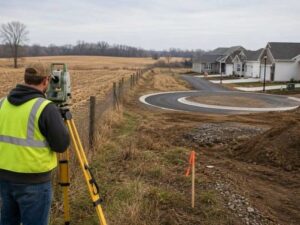
Farmland does not stay farmland forever. A new road opens up, a builder buys the next field over and a quiet tract sits at the edge of town. Land surveying on this kind of property gets hard fast. The old deeds were written for a world of crops and creeks. Now someone wants to build houses, and the paperwork has to catch up.
Tracing Field-Era Descriptions That Were Never Written for Residential Lots
Old farm deeds speak their own language. They rarely use lot numbers. Instead, they describe land by naming the neighbors, the county road, a creek or a big tree at the corner. A line might run “along the lands of” a family that moved away forty years ago. The people who wrote these deeds knew every landmark by heart. They never guessed a stranger would need to follow the words someday.
Long distances add another problem. Old crews measured with chains and compasses, so the numbers can be off by more than owners expect. Surveyors treat the deed like a set of clues with a ranking. Evidence found on the ground usually beats the written numbers. When the two disagree, the surveyor has to show which one wins and why.
Careful reading matters most when the land changes use. A rough description worked fine while one family farmed the whole tract. Once builders start cutting lots out of it, every unclear line can turn into a fight.
Recovering Evidence After Hedgerows and Fence Rows Disappear
Clearing equipment erases history in a day. A hedgerow that stood for sixty years came out in one afternoon. With it goes the easiest clue to where a boundary might run. The surveyor’s job is to find what survives.
Plenty usually does. Iron pins hide a few inches under the dirt. Stones set long ago still sit where someone placed them. Rotten post stubs, old tree lines, ditches and worn paths all show where people once treated a line as real. Crews search for these clues, record each one and compare it to the written record.
Judgment does the heavy lifting here. A fence might follow the true boundary. It might also follow a deal two farmers made over coffee and never wrote down. A surveyor never assumes a visible line control just because it exists. Some old fences match the deed. Others contradict it, and knowing the difference is the whole job.
Connecting Parent Tracts to Newly Created Residential Parcels
Every new lot has a parent. The subdivision plat carves small parcels out of one big tract. That big tract has its own chain of deeds going back a century or more. Good surveying keeps that family tree in one piece.
This means tying new lot corners back to the evidence that defined the original tract. The surveyor never treats the subdivision as a fresh start. Road strips, utility areas and drainage land all take bites out of the parent tract over the years. Each bite has to be counted. Miss one sale in the chain and the leftover acreage stops adding up. That causes trouble for every lot that follows.
Reconciling Acreage Differences Across Deeds, Plats, and Tax Maps
Ask three records how big a tract is and expect three answers. An old deed might say 60 acres. A new plat might show 57.8, and the tax map might show something else. None of this means anyone stole land.
Old deeds often guessed at acreage instead of measuring it. Nobody priced farmland by the square foot back then. Modern tools measure much more closely, so the honest number often differs from the old one. Road takings and small sales also trim tracts over time without anyone fixing the stated total.
Tax maps deserve the most caution. They exist to collect taxes, nothing more. Their parcel lines come from sketches, air photos and office guesses stacked up over decades. A tax map helps a surveyor start research. It never sets a legal boundary, and owners who lean on one alone usually end up disappointed.
Preserving Reliable Corners Through the Next Stage of Growth
Once the boundaries are settled, the goal changes. Now the corners have to stay findable. Streets, homes and landscaping will soon bury the evidence, so the surveyor builds protection into the record first.
Solid markers go in at each corner, set deep enough to survive mowers and grading. Reference ties connect every corner to nearby permanent objects. If a marker gets destroyed, those ties let a surveyor put it back in the right spot. A field survey with clear notes and numbers finishes the package. Future owners inherit answers instead of arguments. The next surveyor on the block starts with a record instead of a rumor.
Frequently Asked Questions
Can an old farm deed still establish boundaries after the land has been developed?
Yes. The deed still matters because it shows what the original owners intended. It never works alone, though. Surveyors read it next to later plats, found markers, newer surveys and whatever evidence the ground still holds. The houses change the view, not the legal foundation.
Why can a newly surveyed parcel contain a different acreage than an older deed states?
Measurement got better, and old deeds often rounded their numbers. Road takings and past sales may have removed pieces that the stated total never subtracted. The boundary lines control the parcel. The acreage adjusts to match the lines, not the other way around.
Should original survey markers be preserved during site clearing?
Always. A marker that has held its spot for decades is proof that money cannot replace. Anyone who finds a possible marker during clearing should stop and call a licensed surveyor before touching it. Protecting a corner costs nothing. Restoring one costs plenty.
For a free land surveying quote, call us at (256) 770-8662 or send us a message by going here.
Posted in land surveying, land surveyor